Making use of detailed topology, real-time traffic, weather, and location of refueling stations and fast-charging facilities, eco-routing strategies have been developed by IFP Energies Nouvelles (IFPEN) to minimize the onboard energy and fuel consumption for both pure thermal and hybrid HD vehicles, and at the same time maximize the electric range considering the travel time and road and traffic restrictions and communicate the possible tradeoffs to the driver. Energy and/or time optimal routes can be proposed to the driver exploiting the OEMs Human-Machine Interface or through a dedicated HMI developed by IFPEN on a tablet.
The functional architecture of the connected features, comprised of the software architecture and interface specification, was set up. Algorithmic development, testing and validation of the features in a simulation environment has taken place too. Furthermore, the associated IT infrastructure (LONGRUN cloud) hosting these features, and demonstration web page based on their current implementation has been setup and deployed.
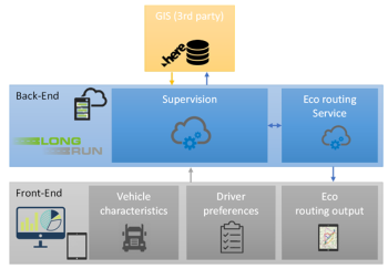
Communication with the cloud, and between the micro-services within the cloud, is done by performing requests. In the Cloud Overview schematic arrows indicate requests and their associated response which materialize in the form of the exchange of files following the .json file format.

Figure 1: Overview of the LONGRUN cloud and the interaction with the consumers (ex. on-board HMI) of the connected features
The LONGRUN cloud demonstration page allows to illustrate and test the connected features. For the eco-routing feature, a 1st version is online, allowing the user to perform eco-routing planning requests.
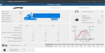
First, the user is asked to enter the vehicle details that will serve for parametrizing the vehicle consumption model:

Figure 2: Eco-routing Demo page: Vehicle characteristics setup
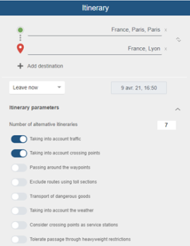
Then, the user enters the mission characteristics: origin and destination points, and the driver preferences for the trip:

Figure 3: Eco-routing Demo page: Driver preferences setup
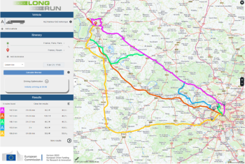
Once the user has set up all necessary information, the eco-routing request is made, and the calculation is performed. In the response, the user receives that various trajectories, alongside with associated information on fuel consumption, mission duration and mission cost including fuel and tolls.

Figure 4 :Eco-routing Demo page: Example results
The functional architecture was defined after exchange and in close collaboration with the leaders and partners of LONGRUN that take an interest in the connected features, in order to render the integration of the connected features in their respective developments straightforward. This includes the demonstrator vehicles work packages, as well as the simulator (WP1) and global Use Cases.
The extensive validation of the intermediate workflow steps of vehicle consumption model and realistic speed profile generation ensure:
- the pertinence of the Eco-routing ranking of alternative routes on the criteria of fuel consumption and CO2 emissions, mission cost and mission duration, providing vehicle operators and drivers with data allowing an informed trip planning process.
- a complement of information destined to the on-board vehicle Energy Management System and range estimation function that allow a more precise estimation of pure electric range in anticipation of Zero Emission zone crossing.
The reported developments will serve as the basis for further testing and validation of the features, including in an HIL implementation, in anticipation of the implementation on-board the vehicle demonstrators of the Eco-routing connected services and Range Estimation. In this context, the preparation work on interface specification with the rest of the WPs is of particular importance for the smooth transition from MIL to HIL and finally to vehicle on-board implementation.
Furthermore, the development of the eco-driving and eco-coaching connected features will be based on the same backbone workflow and infrastructure.